| Apline Lakes:West Home | Contact Infomation | Statistics Explained | Map Information | Scope |
|---|
STATISTICS:
|
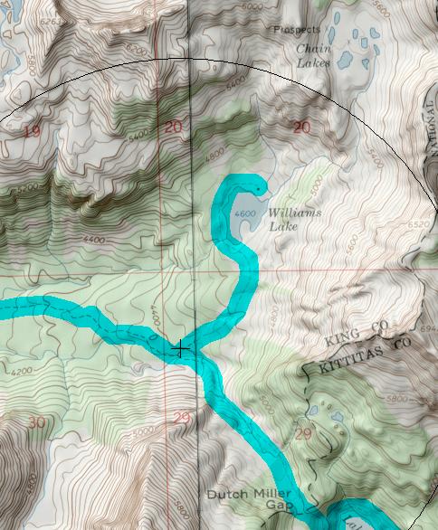
click on map to zoom in for trail location
|
Williams Lake Trail #1031.1 Directions: I-90 to exit 34. Turn north on 468th Avenue. In 0.6 mile, turn right onto the Middle Fork Road #56. Follow Road #56 for 12 miles to the junction, just past the Middle Fork trailhead. Stay on Road #56 by turning right and then left again in one mile. Drive another 11.5 miles to the end of the road. This road is very rough and a high clearance vehicle is recommended.
Hike the Dutch Miller Gap Trail #1030 for 6.5 miles to the junction with the Williams Lake Trail #1030.1. 1
Attractions & Considerations: The Williams Lake Trail winds for one mile through sub-alpine forests and meadows, ending at the lake. The lake sits at the base of Bear's Breast Mountain and offers spectacular perspective to Bear's Breast Mountain and Summit Chief Peak. There are excellent camping sites along the west shore of the lake and plenty of fishing opportunities, as well as berry picking 1
1Source: USFS Trail Guide
return to Alpine West Home Page
Gregg Petrie ©2000