
| Home | Contact Infomation | Statistics Explained | Map Information | Scope | USFS Trail info |
|---|
The purpose of this web site is to provide quick access to selected trail information for the serous hiker for selected trails in the Western Alpine Lakes. This information can be accessed in two ways. The first way is designed to allow you to access the trail descriptions by geographic location by just mouse clicking over the appropriate square in the map. Alternatively you can click on the corresponding row (i.e. trail names for each map id are found in the table) in the associated table. This table is designed to provide a physical context for each trial by giving a short summary of trail statistics.
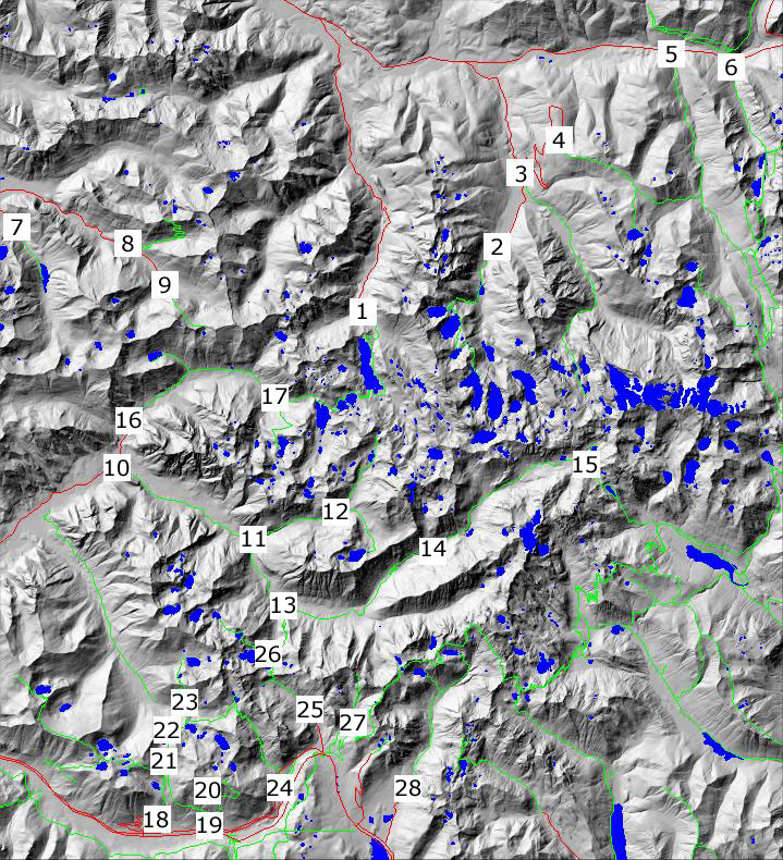
| ID | name | USFS # | miles | Effective miles | Low point | High point |
|---|---|---|---|---|---|---|
| 1 | Dorothy Lake | 1072 | 5 | 7.4 | 2252.0 | 3811.0 |
| 2 | Foss Lakes | 1064 | 6.8 | 11.0 | 1630.0 | 4955.0 |
| 3 | Necklace Valley | 1062 | 7.5 | 11.5 | 1660.0 | 4834.0 |
| 4 | Tonga Ridge | 1058 | 4.6 | 6.4 | 3631.0 | 4756.0 |
| 5 | Deception Creek | 1059 | 10.3 | 14.2 | 1992.0 | 4474.0 |
| 6 | Surprise Creek | 1060 | 4.7 | 7.3 | 2258.0 | 4866.0 |
| 7 | Sunday Lake | 1000 | 1.6 | 2.1 | 1613.0 | 1992.0 |
| 8 | Bare Mountain | 1037 | 4.3 | 7.8 | 2100.0 | 5250.0 |
| 9 | Lennox Creek | 1001 | 2.0 | 4.2 | 2652.0 | 4667.0 |
| 10 | Middle Fork | 1003 | 14 | 16.9 | 1082.0 | 2703.0 |
| 11 | Dingford Creek | 1005 | 5.71 | 8.8 | 1265.0 | 4236.0 |
| 12 | Hester Lake | 1005-1 | 2.51 | 3.6 | 2841.0 | 3919.0 |
| 13 | Rock Creek Trail | 1013-1 | 4.31 | 7.1 | 1608.0 | 4096.0 |
| 14 | Dutch Miller Cap | 1030 | 7.6 | 10.2 | 2817.0 | 4999.0 |
| 15 | Williams Lake | 1030-1 | 0.91 | 1.3 | 4390.0 | 4661.0 |
| 16 | Snoqualmie Lake | 1002 | 10 | 13.3 | 1220.0 | 3776.0 |
| 17 | Nordrum Lake | 1004 | 2.51 | 5.2 | 1830.0 | 3863.0 |
| 18 | Talapus Lake | 1039 | 2.4 | 3.6 | 2637.0 | 3817.0 |
| 19 | Pratt Lake | 1007 | 5.5 | 8.4 | 1877.0 | 4211.0 |
| 20 | Granite Mountain | 1016 | 3.11 | 6.1 | 2587.0 | 5522.0 |
| 21 | Mt. Defiance | 1009 | 6.81 | 9.8 | 3677.0 | 5239.0 |
| 22 | Melakwa Lake | 1011 | 3.21 | 4.6 | 3419.0 | 4494.0 |
| 23 | Kaleetan lake | 1010 | 4.01 | 6.5 | 3021.0 | 4799.0 |
| 24 | Denny Creek | 1014 | 4.4 | 7.5 | 2192.0 | 4664.0 |
| 25 | Snow Lake | 1013 | 3 | 4.6 | 3131.0 | 4413.0 |
| 26 | High Lakes | 1012 | 3.91 | 5.6 | 3937.0 | 4983.0 |
| 27 | CommonWealth Basin | 1033 | 2.6 | 4.3 | 3770.0 | 5361.0 |
| 28 | Gold Creek | 1314 | 5.7 | 7.9 | 2635.0 | 4626.0 |
Return to Hiker.org home page
Gregg Petrie ©2007