| Cle Elum Alpine Lakes Home | Contact Infomation | Statistics Explained | Map Information | Scope |
|---|
STATISTICS:
|
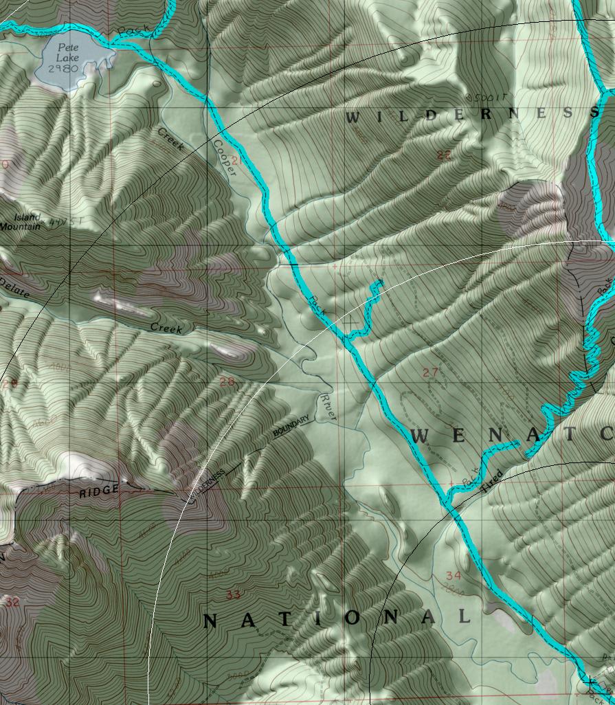
click on map to zoom in for trail location
(Includs the last part of trail 1311 along the lake for reference) |
TRAILHEAD ACCESS: From Cle Elum and/or Roslyn, take State Highway 903 north to the turnoff for Cooper Lake, which is FS Road 46. Follow this to the Cooper Lake turnoff on FS Road 4616 and then left on 4616- 113 to the Pete Lake trailhead.
PARKING AND FACILITIES: The trailhead has parking for numerous vehicles, loading ramp for stock, and toilets. Camping sites are available nearby on Cooper Lake at OWHI walk-in campground or Cayuse Horse Camp at Salmon La Sac. There is no water at the trailhead.
TRAIL: Has a gentle grade for most of its length, with occasional steep stretches. For the first 2.5 miles, it heads up the valley floor through oldgrowth forest, sometimes crossing small creeks. The trail intersects Tired Creek #1317 at 1.25 miles and then Road Tie #1323.1. The latter trail zigzags uphill for 0.5 mile to FS Road 4616 and forms part of a loop route for mountain bikes, (which are prohibited beyond the nearby wilderness boundary on #1323). The main trail continues up valley past the wilderness boundary and in 2 miles comes to Pete Lake and the junction with Waptus Pass #1329. The trail goes around the north shore of the lake and heads uphill through bluffs and forest for 1.3 miles to a junction with Lemah Meadow #1323.2, which takes off to the right (north) and uphill for about 1 mile to Lemah Meadows and a junction with the Pacific Crest Trail #2000.6. The main trail heads south, crossing Lemah Creek ford, and winds uphill through forest and small hills for 0.75 mile to its junction with Pacific Crest Trail #2000.
SETTING: River valley, creeks, old-growth forest, lake, meadows.
OPPORTUNITIES: Hiking, horseback riding, mountain biking (first 2.5 miles only), scenery, photography, berry picking, fishing, hunting, camping.
OTHER TRAILS: Tired Creek #13 17, Waptus Pass #1329, Lemah Meadows #1323.1,
Sheep Camp #1323.4, Pacific Crest Trail #2000.
return to Cle Elum Home Page
Gregg Petrie ©2000