
| Cle Elum Alpine Lakes Home | Contact Infomation | Statistics Explained | Map Information | Scope |
|---|
STATISTICS:
|
click on map to zoom in for trail location
|

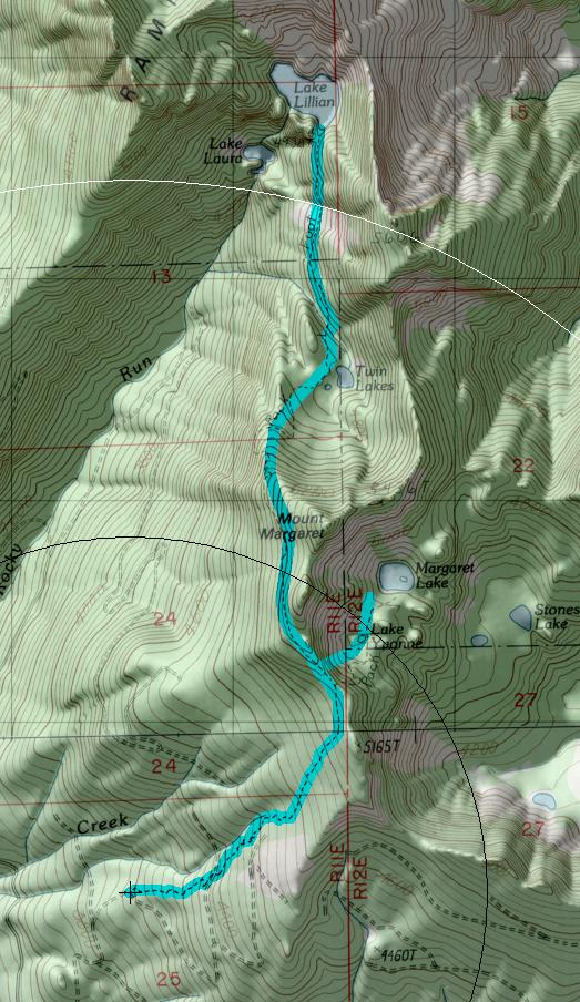
TRAILHEAD ACCESS: Take 1-90 exit 54 and head north and then east on the frontage road which is on the north side of the freeway. Take FS Road 4832 east to Road 4934, then 0.5 mile northeast on 4934 to the trailhead.
PARKING AND FACILITIES: Adequate parking for 20 vehicles. The only facility is a bulletin board with trailhead information.
TRAIL: Follow FS Road 4934 for 100 yards to the first spur left. There is a locked gate here so hike around the gate and follow the road about a mile through a large tree plantation. The trail continues to climb through the clearcut. After entering an old-growth forest, the trail ascends to a ridge and junctions with Lake Margaret Trail #1332.1. Trail #1332 proceeds north descending to Twin Lakes, enters the wilderness and climbs steeply to Lake Lillian. The trail ends at Lake Lillian.
SETTING: Clearcut, old-growth trees, lakes, ridgetops, meadows.
OPPORTUNITIES: Hiking, scenery, photography, camping, fishing, wildlife, berry picking.
OTHER TRAILS: Lake Margaret #1332.1.
return to Cle Elum Home Page
Gregg Petrie ©2000