
| Home | Contact Infomation | Statistics Explained | Map Information | Scope | Background |
|---|
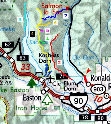 The purpose of this web site is to provide quick access to selected trail
information for the serous hiker for selected trails in the Alpine Great Lakes.
This information can be accessed in
two ways. The first way is designed to allow you to access the trail
descriptions by geographic location by just mouse clicking over the
appropriate square in the map. Alternatively you can click on the
corresponding row (i.e. trail names for each map id are found in the table)
in the associated table. This table is designed to provide a physical
context for each trial by giving a short summary of trail statistics.
The purpose of this web site is to provide quick access to selected trail
information for the serous hiker for selected trails in the Alpine Great Lakes.
This information can be accessed in
two ways. The first way is designed to allow you to access the trail
descriptions by geographic location by just mouse clicking over the
appropriate square in the map. Alternatively you can click on the
corresponding row (i.e. trail names for each map id are found in the table)
in the associated table. This table is designed to provide a physical
context for each trial by giving a short summary of trail statistics.
| ID | name | miles | effort -miles |
Horses | Bicycles | Motor -cycles |
lowest point |
heighest point |
status |
|---|---|---|---|---|---|---|---|---|---|
| 01 | French Cabin Creek --1305 | 1.3 | 2.5 | YES | NO | NO | 3881 | 4899 | Extracted |
| 02 | Domerie Peak --1308 | 10.1 | 16.5 | YES | YES | YES | 2550 | 5460 | Extracted |
| 03 | Littel Kachess --1312 | 4.9 | 6.8 | YES | YES | NO | 2261 | 2515 | Extracted |
| 04 | Kachess Ridge --1315 | 12.8 | 20.8 | YES | YES | NO | 2385 | 5775 | Extracted |
| 05 | Knox Creek --1315.1 | 1.2 | 2.7 | YES | NO | NO | 4152 | 5290 | Annotated |
| 06 | Thorp Creek --1316 | 2.7 | 4.6 | YES | NO | NO | 2605 | 5131 | Annotated |
| 07 | Red Mountain --1330 | 6.1 | 11.9 | YES | NO | NO | 2800 | 5650 | Extracted |
Gregg Petrie ©2000