| Home | Contact Infomation | Statistics Explained | Map Information | Scope | USFS Trail info |
|---|
The purpose of this web site is to provide quick access to selected trail information for the serous hiker for selected trails in the Leavenworth Alpine Lakes. This information can be accessed in two ways. The first way is designed to allow you to access the trail descriptions by geographic location by just mouse clicking over the appropriate square in the map. Alternatively you can click on the corresponding row (i.e. trail names for each map id are found in the table) in the associated table. This table is designed to provide a physical context for each trial by giving a short summary of trail statistics.
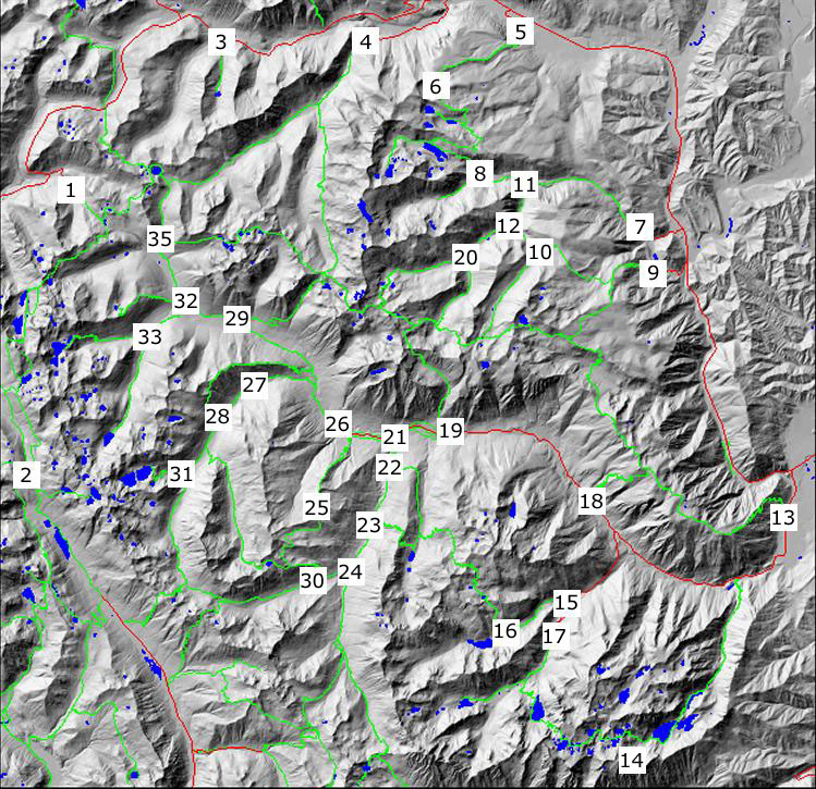
| ID | name | USFS # | miles | Effective miles | Low point | High point |
|---|---|---|---|---|---|---|
| 1 | Tunnel Creek | 1061 | 1.6 | 2.1 | 3049.4 | 4379.8 |
| 2 | Pacific Crest | 2000 | 21.4 | 26.1 | 4034.1 | 5928.3 |
| 3 | Lanham Creek/Lake | 1589 | 1.62 | 2.0 | 3031.0 | 4202.7 |
| 4 | Whitepine Creek | 1582 | 8.6 | 9.9 | 2667.0 | 4654.3 |
| 5 | Gill Creek-Lake Ethel | 1585 | 5.1 | 6.5 | 2347.5 | 5808.6 |
| 6 | Roaring Creek | 1584 | 3.5 | 4.2 | 5115.2 | 5972.9 |
| 7 | Chiwaukum Creek | 1571 | 12.2 | 14.3 | 2162.2 | 6793.9 |
| 8 | Glacier Creek | 1573 | 1.7 | 2.0 | 3850.4 | 4353.5 |
| 9 | Hatchery Creek | 1577 | 6.5 | 8.3 | 2873.9 | 6698.4 |
| 10 | Badlands | 1576 | 5. | 6.0 | 4916.7 | 6154.9 |
| 11 | N. Fork Chiwaukum | 1591 | 6.2 | 7.5 | 3349.5 | 6095.9 |
| 12 | Painter Creek | 1575 | 4.82 | 5.7 | 3656.2 | 6141.1 |
| 13 | Icicle Ridge | 1570 | 26. | 32.7 | 1181.1 | 7314.7 |
| 14 | Enchantment/Snow Lakes | 1553 | 15.3 | 18.9 | 1288.4 | 7830.3 |
| 15 | Eightmile Lake | 1552 | 3.3 | 3.8 | 3287.9 | 4637.9 |
| 16 | Lake Caroline | 1554 | 8.0 | 10.0 | 4425.4 | 7245.2 |
| 17 | Stuart Lake | 1599 | 5.1 | 5.9 | 3428.6 | 5112.9 |
| 18 | 4th of July Creek | 1579 | 5.3 | 7.4 | 2258.6 | 6766.3 |
| 19 | Chatter creek | 1580 | 5. | 6.7 | 2948.4 | 6651.2 |
| 20 | Index Creek | 1572 | 2.8 | 3.1 | 4123.0 | 4796.0 |
| 21 | Jack Creek | 1558 | 10.9 | 12.7 | 2807.7 | 6146.4 |
| 22 | Trout Creek | 1555 | 4.6 | 5.4 | 3517.1 | 4787.8 |
| 23 | Trout Lake | 1557 | 3.5 | 4.6 | 3689.0 | 5749.8 |
| 24 | Meadow Creek | 1559 | 6.2 | 7.2 | 3705.4 | 5374.9 |
| 25 | Blackjack Mtn. | 1565 | 8.0 | 10.6 | 2896.9 | 6735.8 |
| 26 | Icicle Creek | 1551 | 11.93 | 13.4 | 2846.1 | 4973.1 |
| 27 | French Creek | 1595 | 14.4 | 16.8 | 2881.2 | 6100.8 |
| 28 | French Ridge | 1564 | 7.2 | 9.1 | 2950.7 | 5760.7 |
| 29 | Frostry-Wildhorse | 1592 | 10.6 | 12.6 | 3172.4 | 5825.0 |
| 30 | Snowall-Cradle Lake | 1560 | 9.1 | 10.9 | 3332.8 | 6404.2 |
| 31 | Klonaqua Lake | 1563 | 2.1 | 2.8 | 3700.8 | 5173.2 |
| 32 | Leland Creek | 1566 | 5.3 | 6.2 | 3226.2 | 4562.5 |
| 33 | Square Lakes | 1567 | 3.5 | 4.4 | 3407.3 | 5168.6 |
| 34 | Lorraine Ridge | 1568 | 4 | 5.3 | 3233.8 | 5424.8 |
| 35 | Chain Lakes | 1569 | 4.5 | 5.8 | 3799.9 | 6271.0 |
Return to Hiker.org home page
Gregg Petrie ©2007