The purpose of this web site is to provide quick access to selected trail
information for the serous hiker for selected trails in the Cle Elum Alpine Lakes.
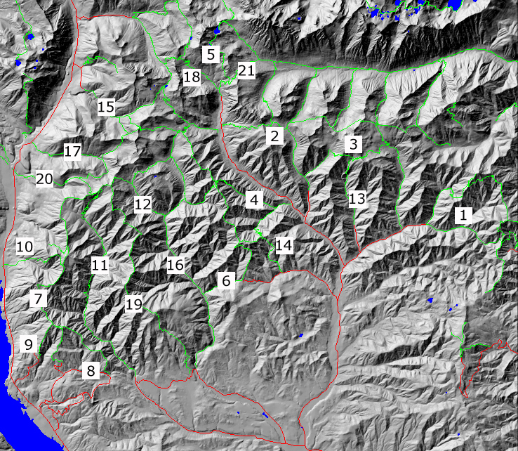
This information can be accessed in
two ways. The first way is designed to allow you to access the trail
descriptions by geographic location by just mouse clicking over the
appropriate square in the map. Alternatively you can click on the
corresponding row (i.e. trail names for each map id are found in the table)
in the associated table. This table is designed to provide a physical
context for each trial by giving a short summary of trail statistics.
| ID |
name
(links to old discription) |
Length(m) |
max. gain(ft) |
Trail Tritter |
Links |
| 1 |
Miller Peak(#1379)-
Iron Bear(1351) |
11.9 |
2400 |
Hiking season: July through Sept. |
USFS-1379,
USFS-1351,
Cle Elum Trails,
map,
location,
profile
|
| 2 |
Beverly(1391)-
Iron Peak(1399) loop |
7.0 |
2544 |
Good views down the valley from the ridge. |
USFS-1391,
USFS-1399,
Cle Elum Trails,
map,
location,
profile
|
| 3 |
Bean Creek(1391.1)-
Stafford Cr.(1359)loop |
10.8 |
3150 |
Good views from the ridge campsite. |
USFS-1391.1,
USFS-1359,
Cle Elum Trails,
map,
location,
profile |
| 4 |
Johnson Medra #1383 |
6 |
2200 |
Best Seaons: Summer,Fall |
USFS-1383,
map,
location,
profile |
| 5 |
Ingalls Lake #1390(+1394) |
4.4 |
2300 |
May have to fight the crowds to get to the most beautiful lake in the region |
USFS-1390,
map,
location,
profile |
| 6 |
Way Creek #1235 |
4.9 |
1800 |
This trail is steep and rugged. |
USFS-1235,
map,
location,
profile |
| 7 |
Sasse Mt. #1340 |
9. |
2100 |
Difficult |
USFS-1340,
map,
location,
profile |
| 8 |
Corral Creek #1340.1 |
3.4 |
2040 |
Difficult |
USFS-1340.1,
Cle Elum Trails,
map,
location,
profile |
| 9 |
Hex Mt #1343 |
1.5 |
1500 |
long slog rewarded by 360 degree views |
WTA,
map,
location,
profile |
| 10 |
Howson Creek #1349 |
3.5 |
2950 |
Difficult |
USFS-1349,
Cle Elum Trails,
map,
location,
profile |
| 11 |
West Fork #1353 |
9.6 |
2950 |
Difficult |
USFS-1353,
map,
location,
profile |
| 12 |
Jolly Creek #1355 |
3.1 |
2500 |
Most Difficult |
USFS-1355,
map,
location,
profile |
| 13 |
Standup Creek #1369 |
3.8 |
3100 |
Open to hikers, horseback, bicycle |
Cle Elum Trails,
map,
location,
profile |
| 14 |
Jungle Creek #1383.1 |
4.5 |
1600 |
Stream open hillsides, ridgetop, stands of moderate sized trees |
USFS-2383.1,
map,
location,
profile |
| 15 |
Boulder-De Roux #1392 |
7.9 |
1760 |
Features Gallagher Head (Enis) Lake |
USFS-1382,
Cle Elum Trails,
map,
location,
profile |
| 16 |
Middle Fork Teanaway #1393 |
12.0 |
3120 |
Moderate |
USFS-1393,
map,
location,
profile |
| 17 |
Paris Creek 1393.1 |
8.0 |
3100 |
While much of this tail is in
good condition, portions are steep and narrow |
USFS-1393.1,
Cle Elum Trails,
map,
location,
profile |
| 18 |
Esmerelda Basin #1394 |
5.1 |
2150 |
SETTING: Creek valley, meadow, forest, ridgetop, lake |
USFS-1394,
Cle Elum Trails,
map,
location,
profile |
| 19 |
Yellow Hill #1222 |
9.8 |
2630 |
Difficult |
USFS-1222,
map,
location,
profile |
| 20 |
Jolly Mt #1307 |
6.2 |
3980 |
Moderate |
USFS-1307,
map,
location,
profile |
| 21 |
Longs Pass #1229
(+1394&1390) |
1 |
700 |
Easy |
USFS-1229,
map,
location,
profile |
Return to Hiker.org home page
Gregg Petrie ©2000
|